Roman aqueducts

Brian G Turner

Fantasist & Futurist
Staff member
Supporter
Joined
Nov 23, 2002
Messages
26,431
Location
UK
What a riveting sounding title! But I'm a complete Romano-phile, so I'll cover anything on the topic. ;)

Also in preparation for the History board that I'll be creating soon.

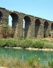
Anyway, this article refers to how the Romans created holes and hurdles in their aquaducts to help reduce turbulence and keep a smooth flow of water.
 
Last edited:
2000 plus years later , the Acqua Vergine Aqueduct is still us. A testament to the Romans great engineering skills.:cool:(y)
 
Yeah, but apart from the aqueducts, what have the Romans ever done for us?

The Pantheon building in Rome which is by far the best preserved Roman Building of all.:) Roman Law and organization is one of the pillars of Western Civilization. :unsure: :)


I think that as topics go , this one is quite interesting and deserves a revival because it also doesn't have time limitations on it. :)
 
Last edited:
One of the prettiest examples of Roman aqueduct is the Pont du Gard, built about 2000 years ago in the beginning of the 1st century and still in pretty good nick.

1656875068198.png

It bridges the valley of the river Gard (surprisingly)and is only about 2 1/2 hours drive from a rather more modern bridge over the river Tarn, and also quite impressive, if less Roman.


Le viaduc of Millau, designed by Norman Foster, carries the A75 motorway, rather than water and was completed 18 years ago. It has a slightly different construction.

1656875853883.png
 
One of the prettiest examples of Roman aqueduct is the Pont du Gard, built about 2000 years ago in the beginning of the 1st century and still in pretty good nick.

View attachment 91054
It bridges the valley of the river Gard (surprisingly)and is only about 2 1/2 hours drive from a rather more modern bridge over the river Tarn, and also quite impressive, if less Roman.


Le viaduc of Millau, designed by Norman Foster, carries the A75 motorway, rather than water and was completed 18 years ago. It has a slightly different construction.

View attachment 91056
When I was a kid I walked along the top of the P du G. No railings or anything. I dont think you can do that anymore.
 
When I was a kid I walked along the top of the P du G. No railings or anything. I dont think you can do that anymore.
You could certainly walk the second floor about 10 years ago when I was last there, but I'm not sure about the top (third floor), which is where the water flowed.
Incidentally, if you ever go, visit the town of Uzes, which is right nextdoor and is also lovely.
 
You could certainly walk the second floor about 10 years ago when I was last there, but I'm not sure about the top (third floor), which is where the water flowed.
Incidentally, if you ever go, visit the town of Uzes, which is right nextdoor and is also lovely.
In the early 80s you could walk right along the top. Health and safety were conspicuously absent. There were regular gaps where you could climb down into the water channel, covered by the top slabs, if you got too freaked out. As far as I remember it was possible to walk through the channel upright, but it was a long time ago and I was in my teens.
 
I've always wondered how watercourses were surveyed without modern instrumentation, i.e. how did they ensure a continuous gradual downward gradient over many miles? I've very familiar with the leats on Dartmoor, the first of which was built under the supervision of Sir Francis Drake, running from Dartmoor down to Plymouth on the coast, a distance of 17 miles. The leat follows the contour lines, but of course these were not shown on maps of that era.
 
I've always wondered how watercourses were surveyed without modern instrumentation, i.e. how did they ensure a continuous gradual downward gradient over many miles? I've very familiar with the leats on Dartmoor, the first of which was built under the supervision of Sir Francis Drake, running from Dartmoor down to Plymouth on the coast, a distance of 17 miles. The leat follows the contour lines, but of course these were not shown on maps of that era.
The Romans had a thing called a Chorobates[?], that was basically a long table that you could adjust so you knew the angle it was at and then look along to plan the next bit of your route.
There is a great [kids] book City, Castle, Cathedral; An Introduction To Architecture by David Macaulay. It takes you through how to build a Roman city, a medieval [English but in Wales] Castle and a Gothic Church. It covers everything from surveying, to building and beyond.
 
@Aquilonian You may already know this, but worth mentioning.
With determination, creativity and observation, we humans have done some amazing things in the past with the simplest of tools.
5 Tools Used By The Ancient Romans To Build Their World-Famous Roads.

Just as an example with no intentions of high jacking this post:

Even Chaco Canyon here in the states is an ancient engineering wonder. Stonework that equals and rivels that of Europe/mid-east of that time. The Sun Dagger, the design and layout of the pueblos. Plus being the largest ancient solar/lunar calendar/tracking observatory in the Americas at 20 by 30 miles'ish (+-). All done without the tools the Romans and Egyptians used.
6 Mysterious Ruins at Chaco Canyon: Decode the Sun Dagger Petroglyph

What I'm trying to say is looking at the two, with a single stick and a string, you can build Chaco Canyon. But with a right-angle stick and a string attached, you can conquer and bring water the known world.

Maybe a little out of bounds so forgive me everyone!:)
 
I've always wondered how watercourses were surveyed without modern instrumentation, i.e. how did they ensure a continuous gradual downward gradient over many miles? I've very familiar with the leats on Dartmoor, the first of which was built under the supervision of Sir Francis Drake, running from Dartmoor down to Plymouth on the coast, a distance of 17 miles. The leat follows the contour lines, but of course these were not shown on maps of that era.
Rivers manage to do it quite well!
 
Mentioning Roman Roads I read a beautiful book on them many years ago from a library. Big book, lots of photos, chapter per road plus introductory chapters on building.
There was this wonderful story of Napoleonic Army engineers surveying the Atlas mountains for a good passage for the army. Followed what seemed the best route up, general attitude of "hey wow, we're the first here" and "this is not a bad route" then at the crest of the mountain pass they found a carved way marker that said which Roman legion had built a road through there. OKaaay.
 

Similar threads


Back
Top