Anyone here do their own maps?

I just reread Dune and didn't even realize there was a map and there is a second image on my copy because it's on the dust jacket.
My 1966 hard set of LOTR has a map that I've looked at once- just now to be sure it was still there.
I'm not so hot on maps and glossaries and appendices.

But, hey, knock yourself out.
 
I do love a map, mainly real ones but also fictional ones when they're done well.

I did create an obscene map for my trunked novel The Boy With Jewels In His Eyes and its sequels. I've attached the draft. The lighting for the pictures I took was awful, so it looks a bit odd. My intention was to redo this in full colour, with artwork.
 

Attachments

  • Map Of All Eldverold - HiRes.jpg
    Map Of All Eldverold - HiRes.jpg
    2.3 MB · Views: 248
I've attached the draft.
Is it because the phrase, Prints Caspian is running through my mind...?

;):)


I've produced a number of maps to help me. I very much doubt that I'd include them in the books: they look better in colour and are more suitable for display on a website associated with the books.
 
Here is one of mine. Stuck on changing it because I'm wondering if it's too close together for one country to still be run by Kings and the other to be full parliament with tramlines, and railways. (ALEXIAMDRA and IRANDI)

Second is the world map. Which I'm thinking on splitting up into separate landmasses. And the last one is a city under construction. I like maps, a lot.
 

Attachments

  • Irandi and Alexiamdra.jpg
    Irandi and Alexiamdra.jpg
    447.8 KB · Views: 237
  • Geological map of Onchara.jpg
    Geological map of Onchara.jpg
    503.1 KB · Views: 211
  • NEW CARAKSAND.jpg
    NEW CARAKSAND.jpg
    979.5 KB · Views: 241
Stuck on changing it because I'm wondering if it's too close together for one country to still be run by Kings and the other to be full parliament with tramlines, and railways.

There are still plenty of monarchies and backwards countries around.
 
Here's one of mine (with most of the names removed, so their illegibility isn't an issue with this low-res jpeg). The original is a PowerPoint file.

Sekhemkhet - cropped - no names.jpg

This is the only map that indicates the contours of the land**; others include a road map covering various states, a general overview of a completely different territory, and ones showing cities (with their districts and main transport arteries).


** - Once bitten, twice shy?

 
I have a few of Mayhem's country and world on my other hard-drive. I wrote the first book without it but the second needed it for me to keep track of what I had done and where. Whether I'll include them on my blog I don't yet know.
 
@RX-79G, yes but countries of lower technological progress are not likely to be right next to a country of higher technological progress, unless there is something specific hampering the natural spread of development. Could you imagine modern-day France being an absolutist monarchy from the 17th century where everything is still done with horse and cart when right next doors people are getting on trains in Germany?

@anthorn Now, I'm not saying it's impossible, but it would need a good reason. Something like the Iron Curtain could work as an example, if the monarch is trying to keep his people out of the know, because he would otherwise lose power etcetera, etcetera. Give it a good reason, and you can make almost anything work.

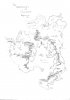
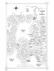
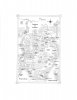
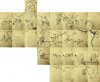
I make a lot of my own maps. I draw them a lot, but that is also because I just draw in general. I don't draw maps for the sake of having maps, but for the sake of drawing something I enjoy. Besides that, I also enjoy just creating new cultures, for which a map is really helpful to me.

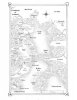
I'm not too bothered by maps in fantasy novels. I don't really mind if the map has no real bearing on the story, though I appreciate it more if it does have that. The thing that irks me is that most maps are too... neat. They're never wonky. They always seem to be an accurate representation of the world. A map would be more interesting to me if it was less accurate, if that makes sense. If it were to become a lens through which the characters might see the world, rather than a bit of extra fluff (Look at Jerusalem on some medieval European maps, for example).

I like accurate maps in an atlas, but in a novel I would prefer a more storied map.
 
If the story is a quest-type adventure that involves a large amount of travel, I feel cheated if the author is unwilling to provide a map I can follow along with. It comes across to me that the writer either didn't know how to create a map, or wasn't willing to pay someone to create one for them. It's as if the writer/author is unwilling to go the extra mile. To my mind, especially in epic fantasy, maps are an absolute necessity, and a gift to the reader.
 
I like them, especially in stories that involve a lot of travel or conflict between regions. My visual imagination isn't that great, so it can be hard to hold several different places in my mind while I read and remember how they relate to one another. That goes for writing, too. I make my own maps to help me visualize where everything is, but they're often wildly inconsistent in terms of distances and need some work in that respect. (Also, I agree that the thought of flawed/biased maps is appealing; I play with that in my writing, though I haven't actually drawn any of those ones yet...)
 
Here are the three maps that show the continent of Ardmore and the distant lands to the west and east.

I drew these maps for my epic-fantasy series, “The Blood-Rune Saga”. Book #1, THE UNNAMED RUNE is already available through Amazon, Barnes & Noble, and all the Smashword sites. Book #2, A DIRE ONUS, will be available at these same sites around the beginning of April 2017.

To my mind, epic-fantasy is greatly improved by a map that readers can refer to. It gives them a picture of the world, including the topographical terrain – mountains, rivers, deserts, oceans and seas, and the various towns and cities -- and how each region relates to the entire scope of the world.

I don’t know about other readers, but I always find a map helpful, no matter how well a story is written. If feel it’s a gift to me as a reader when an author gives me the luxury of a well-defined map.

Below, you will find the maps of my world. I hope you enjoy them.
 

Attachments

  • (2-14-17) Final Western Map jpg.jpg
    (2-14-17) Final Western Map jpg.jpg
    3.1 MB · Views: 334
  • (2-14-17) Final Continental Map jpg.jpg
    (2-14-17) Final Continental Map jpg.jpg
    1.9 MB · Views: 318
  • resized (2-14-17) Final Eastern Map jpg - Copy.jpg
    resized (2-14-17) Final Eastern Map jpg - Copy.jpg
    54.2 KB · Views: 160
Last edited:
For crying out loud!!! The last half of that last sentence above should've read: "...,I really have to leave right now." I guess I was in a bigger hurry than I realized.

Also, I've proven I don't know how to spell "I", either -- it seems I believe the letter "f" is part of the one-letter word "I". The post with the three maps makes that obvious.

Clearly, I have to invest more time in practicing my writing skills. What a maroooon!

And it's so strange...because up to this point in my life, I've never made any mistakes. But I guess there's always a first time. :)
 
Clearly, I'm hopeless. The problem was with the word "If", which should've been "It". I'm trying to get the second volume of my epic fantasy series e-published, and it has my brain more scrambled than usual. Sorry for all the mistakes. I'll try to do better in the future when my stress level is reduced.

Thanks for your patience and understanding.
 
In my current work, which is an "epic fantasy quest" story across a continent equivalent to Eurasia, I need a map, or I'm more lost than my characters. Putting it in the first book would be a bit spoilery but given the size of the landscape I might chop it up and put in sections relating to where the characters are on the map.

Which brings me to the problem with mapmaking, familiar to anyone who dabbles in cartography: going from a macro to a micro view. Free services like Inkarnate (which I love, for what it does) is best for micro maps, less than 200 miles across IMHO. Powerful mapping programs like Fractal Mapper (which I also love) are a bit better for super-large continent maps but then are crap for dialing in to, say, a port city.

I might be stuck going into Illustrator to do this in a way where I zoom in and out of the landscape as needed. I kind of don't want to do that, I'm hardly a pro at Illustrator, but needs must? Woe!
 
My daughter was reading one of my manuscripts last year and she said the busy battle on the fourth day would be helped by some battle maps. She and her husband are in the design and illustration fields so they created five maps for me. I rough sketched what I wanted and they took it from there. They have been well received. In the sequel, a much simpler story, we just added two maps. It was for continuity's sake if nothing else.
 

Back
Top